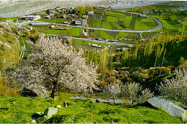
Shigar fort is built upon a huge rock therefore it is locally known as fongkhar, the fort on the rock. The Fongkhar is at a height of 2250 Metres, located in the emerging township of Shigar on the route to the Baltoro glacier and the famous 8000 metre peaks of K-2 Gasherbrum and Broad peak, 28 k/m from Skardu the principal town in Baltistan. The Fongkhar is located on the right bank of shigar stream, which divides Shigar into two main portions and flows into the Shigar river which then joins the Indus river near Skardu. The area in which fongkhar is built is called Nanglonpa in the lap of the rock tower on which the main stronghold of the Amachas (the ruling dynasty) of Shigar was situated and now only some ruins are left.
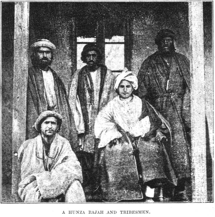
According to various writers and the present raja Hassan khan the 20th ruler of the Amacha dynasty constructed fongkhar. The Amacha dynasty has its origins in the Hamacha tribe of Ganish Hunza and it is most likely that a young man from Hunza with the name of Amacha came to Shigar using the then passageway across the Hispar glacier the Nunshik pass and the Arundo valley. Some writers believe that as the Hamacha tribe was massacred in Hunza some members of that tribe manage to flee to shigar where they gained power and got recognized as the Amacha in the 13th -14th century.
Hassan khan ascended the throne in 1634, and with the permission of the Moghuls brought various artisans including shawlweavers, carpenters, goldsmiths, stone- carvers from Kashmir to Shigar. The Fongkha was a huge cribbage structure of three stories built on a massive platform using the huge rock as its foundation. Now it is in a state of shambles and disrepair, the present raja Mohammad Ali shah did not have the wherewithal to repair and maintain it.
In 1999 the raja of Shigar gifted the fort into the public domain and AKCSP initiated emergency repair work in 99. This fort after restored will be used as and exclusive guesthouse and museum. The work will complete in the year of end 2003. Baltit Fort
 Baltit Fort or Balti Fort is an ancient fort in the Hunza valley in the Northern Areas of Pakistan. In former times survival of the feudal regimes of Hunza was ensured by the impressive Baltit fort, that sit on top of Karimabad. The foundations of the fort are said to date back around 700 years, but there have been rebuilds and alterations over the centuries. In the 16th century the Thum married a princess from Baltistan who brought master Balti craftsmen to renovate the building as part of her dowry. The architectural style is a clear indication of Tibetan influence in Baltistan at the time.
The Mirs of Hunza abandoned the fort in 1945, and moved to a new palace down the hill. The fort started to decay and there was concern that it might possibly fall into ruin. Following a survey by the Royal Geographical Society of London, a restoration programme was initiated and supported by the Aga Khan Trust for Culture Historic Cities Support Programme. The programme was completed in 1996 and the fort is now a museum run by the Baltit Heritage Trust.
Historical Background
 In olden times a number of small independent states existed in the history of Northern Areas of Pakistan. Among them Hunza and Nager were the traditional rival states, situated on opposite sides of the Hunza (kanjut) river. The rulers of these two states, known as Thámo / Mirs (Thάm=S), built various strongholds to express their power. According to historical sources (Ref: Tarikh-e-Ehd Atiiq Riyasat Hunza by Haji Qudrarullah Baig, Pub: S.T.Printers Rawalpindi 1980 Pakistan), the Hunza rulers initially resided in the Altit Fort, but later as a result of a conflict between the two sons of the ruler Sultan, Shah Abbas (Shάboos) and Ali Khan (Aliqhάn), Shaboos shifted to the Baltit Fort, making it the capital seat of Hunza. The power struggle between the two brothers eventually resulted in the death of younger one, and so Baltit Fort further established itself as the prime seat of power in the Hunza state.
The rich beauty of Baltit Fort can be traced to over seven hundred 700 years ago. Ayasho II, Tham / Mir of Hunza in the early 15th fifteenth century married Princess Shah Khatoon (Sha Qhatun) from Baltistan (In Moghul history Baltistan is called Tibet Khurd mean, little Tibet), and was the first to modify the face of Altit and, subsequently Baltit Fort. Baltistan meaning land of Balti people had a very strong cultural and ethnical relation with the Ladakh territory of India then. Consequently, the structure of Baltit Fort was influenced by the Ladakhi / Tibetan architecture, with some resemblance to the Potala Palace in Lhasa. Then additions, renovations and changes to the building were being made through the centuries by the long line of rulers of the Hunza that followed.
 A veritable treasure house for ancient forts, the Northern Areas of Pakistan lost most of its glorious built heritage around the 19th century as a result of the destructive attacks by the Maharaja of Kashmir. However, in this regard people of Hunza were exceptionally fortunate to successfully defend against the invasions of Maharaja Kashmir four times. One of the biggest changes in the structure of Baltit Fort came with the invasion of the British in December 1891. Tham / Mir Safdarali Khan, ruler of Hunza his wazir Dadu (Thara Baig III), fled to Kashgar (China) for political asylum with their fellows and families. With the conquest of Hunza and Nager states by the British forces in December 1891, the fortified wall and watch towers of the old Baltit village and watch towers of the Baltit Fort on its north-western end were also demolished as desired by the British authorities. The British installed his younger brother Tham / Mir Sir Muhammad Nazim Khan K.C.I.E, as the ruler of Hunza state in September 1892
During his reign, Tham / Mir Nazeem Khan made several major alterations to the Baltit Fort. He demolished a number of rooms of third floor and added a few rooms in the British colonial style on the front elevation, using lime wash and colour glass panel windows. The Baltit Fort remained officially inhabited until 1945, when the last ruler of Hunza, Mir Muhammad Jmamal Khan, moved to a new palace further down the hill, where the present Mir of Hunza Mir Ghazanfar Ali Khan (Current Chief Executive of Northern Areas) and his family are residing.
With no proper authority entrusted to care for it, the Fort was exposed to the ravages of time and over the years its structure weakened and began to deteriorate. His Highness Aga Khan IV initiated the restoration efforts for Baltit Fort in 1990, when Mir Ghazanfar Ali Khan the son of last ruler of Hunza, Tham / Mir Muhammad Jamal Khan and his family generously donated the Fort to the Baltit Heritage Trust, a public charity formed for the explicit purpose of owning and maintaining the Fort. The restoration undertaken by the Aga Khan Trust for Culture in Geneva in association with the Aga Khan Cultural Service Pakistan (Pakistan), took six years to complete. The project was supported by the Aga Khan Trust for Culture as the main donor through its Historic Cities Support Programme, as well as by the Getty Grant Program (USA), NORAD (Norway) and the French Government.
 The restored Fort, resplendent in its regal glory was inaugurated on September 29, 1996 in the presence of His Highness the Aga Khan IV and the president of Pakistan Farooq Ahmad Khan Laghari. It is now operated and maintained by the Baltit Heritage Trust and is open to visitors. Preservation at its best, the Baltit Fort serves as a perfect example of culture restored and preserved for the future generations of the mountain people.
Awards and recognition
- 2005 Time Magazine Asia, Best of Asia Award
- 2004 UNESCO Asia-Pacific Heritage Awards for Cultural Conservation Award of Excellence
- 2000 Tourism for Tomorrow Awards: Global Winner
Bibliography
- Baig Qudratullah, Tarikh-e-Edh Atiiq Riyāsat Hunza Pub: S.T.rinters Rawalpindi-Pakistan 1980
- Dani A.H, History of Northern Areas of Pakistan Pub: Sang-e-Meel Publications, Lahore Pakistan www.sang-e-meel.com, Reprinted: 2007).
- Biddulph John, Tribes of Hindoo Koosh Pub: The Superintendent of Government Printing-Calcutta India 1880, Reprint: Ali Kamran Publishers, Lahore-Pakistan 1995.
 Altit Fort is situated in the village of Altit, about 3 km from Karimabad. It has been built on a sheer rock-cliff that falls 300 meters (1000 feet) into the Hunza River, and is about 100 years older than the nearby Baltit Fort.
Karakoram Highway
 The souls that paved the way for the modern tarmac road named the Karakoram Highway still seem to flicker amongst the sharp moving shadows of the unstable rocks and the almost countless but crumbly lucent glaciers that constantly threaten it's existence. There has always been a long pass into, and out of China over what is sometimes called the 'roof of the world' but in ancient times it was a very perilous pathway.
Extant writings, etched in a fourth century A.D. Chinese travelers diary, record ' The trail was very precipitous, and vertigo accompanied us as we edged along it...' The path was certainly narrow, and often clung to the sheer faces of the many deep resonant gorges that still confine their turgid, animated rivers. Even today, one can still see vestiges of an old crumbling trail high up above the present road. Although it is not the same trail that this particular merchant scrabbled breathlessly along, if one scrambles up to it and edges along it for a few meters, one can experience the same feelings of dizziness and danger that the diarist wrote about.
The new wide metal led road also winds along high palisade like cliffs in some places, and sometimes short sections of the tarmac rumble down into the river below or become buried under tones of rock and mud. However a modern traveler on this modern road will not experience the same fear or vertigo as the ancients.
The present highway is also popularly called the 'Silk Route' by many romantics because it approximates the trail of what was once one of the many silk, jade and spice carrying caravan trails that congregated somewhere near Xian, in China, and terminated in the vicinity of modern Syria on the Mediterranean sea coast. Like long lines of exploring ants, determined traders, merchants, and adventurers wore a path through narrow gorges, high grass sheathed valleys, across waterless deserts, around 6,000 meter - and higher mountains, and over raging rivers in pursuit of barter.
 The passage of time hasn't altered any of these geophysical conditions, nor were the reasons for building this new road (apart from its obvious military significance) any different from the ancients reasons for undertaking such a hazardous journey. The new road was built to facilitate trade between China and Pakistan.
Tourist literature published by the Pakistan Tourist Authorities states that the road took twenty years to build. The pamphlets also mention the amount of earth moved, rocks blasted out of the way and more poignantly, the number of men and women, both Pakistani and Chinese who died in this great joint engineering feat.
Although the brochures write that it 'took twenty years to build', the road is in fact never finished! Because of the uniqueness of it's geophysical surroundings, constant natural activity frequently destroys sections of the highway. A small army of workers are on hand to reroute the road and join the new sections to the ends of the undamaged highway. The road in other words, is constantly being moved!
Put very simply, the road meanders through an area where highly active tectonic plate pressure is causing mountains to grow faster than the elements can wear them down! Swift flowing rivers and the measurable movements of glaciers crush, undercut and wash away the sides of these same mountains contributing to the constant rock falls and landslides that changes the face of the land almost daily! This uniquely accelerated geological activity can be felt, seen, and heard if one sits quietly on any high vantage point for a few hours. The road is in fact an observable reflection of man's incessant, but unequal struggle against nature's transcendental power.
Starting near Rawalpindi, the bitumen sealed motorway winds through gently rolling, sandy foothills for approximately one hundred and twenty kilometers before intersecting the Indus river. (Called the 'Sind' by the Urdu language speaking Pakistanis) it then twines along the Indus's arc north eastward to within forty kilometers of the town of Gilgit.
 Between these two points, (about four hundred kilometers) the road sometimes takes on a 'roller-coaster' aspect as it dips into, and out of the Indus's wide river bed. The final dip is at this forty kilometers point when the road joins the Gilgit river and continues to within twelve kilometers of the town of that name, then swings North, crossing the Gilgit river to join the Hunza river. The town of Gilgit is twelve kilometers off the actual Karakoram highway and is reached by a fairly smoothly laid and slightly inclined tarred road.
Although the Karakoram Highway inclines upwards the whole way to the pass it's not until you get close to Gilgit that you begin to feel as if you are in mountains. Even so, the town is only at one thousand, five hundred meters (approx. five thousand feet) elevation and there is still a feeling of being in desert. The barren, dust laden and tan colored hills that surround the area give the impression of being made from sand, however, it only takes a ride of a couple of kilometers north from Gilgit for one to get the impression of being in 'real' mountains - very high, and very sheer mountains.
This is not to say that the actual road itself is steep - it's not, it's just that the demarcation between the almost sand dune like foothills, and the seemingly abrupt line of six to eight thousand meters high glacier and snow plaited mountains is almost overpoweringly awesome.
The road then accompanies the Hunza river through these mountains, climbing gently almost all the way to the 4,700 metre high Khunjerab Pass. Only during the last twenty-odd kilometers from the top of the pass will you find short stretches of consistently steep road gradients of six to fourteen degrees. At the top of the pass, two tall memorial stones show that this is the convenient dividing line between political Pakistan, and political China. Both countries respective customs and immigration posts are some kilometers away on their respective sides of the pass. Sust, the Pakistan customs post is ninety kilometres before the peak. Tax organ, the Chinese customs post and town of that name, is one hundred and thirty kilometers from the peak.
 The pass also separates two differently named mountain ranges, the Karakoram range (on the Pakistani side), from the Pamir in China. Within these two massive ranges, there are other named but smaller clusters of rugged mountains, and a quick glance at a map can confuse one as there is no illustrated way that one can separate one range from the next.
On the Chinese side of the pass the road is given a different name by the Chinese, who call it, loosely translated, 'The Big Pakistan/China Friendship Road'. This continuation of the Karakoram is also smoothly finished and well graded. It scrolls up and down through generally wide valleys for approximately four hundred and fifty kilometers to the camel market town of Kashgar, which is in the mostly Taklamakan desert filled Chinese province of Xingjian.
As most travelers consider the Karakoram highway and the Big Pakistan-China Friendship Road to be one and the same, I have done so in this guide, with the exception that I refer to the Chinese road's by their route numbers. All Chinese roads have designated route numbers and periodic 'kilometer' markers tell you what numbered road, or track you are on at any given time, for example, the Chinese side of the Karakoram road is route number 314, and you can stay on this route half way across China.
The actual kilometer numbers on the stones don't seem to make any sense, and they certainly did not usually reflect accuracy as compared to both of our cyclometers, which always came out to within a hundred or so meters of each another at the end of every day. The numbers on the stones often showed a ten or fifteen kilometer difference to our daily total.
Ganish Hunza
 Six kilometers (4 miles) beyond Aliabad, the KKH makes a sweeping S-bend down past Ganish village to the bridge across the Hunza River. Ganesh, on fertile flat and above the river, is guarded by an old watchtower and fort. The old craved mosque is also worth a visit. In the pool in front of the tower all the local children learn to swim. Until this century boys had to swim across the Hunza River to prove that they could escape or attack across the river when necessary. Until the British came in 1891, the men of Hunza used to keep a sword, gun, shield and a loaf of bread (which was replaced every eight days) beside their doors; when the drums beat the alarm from Altit fort, heralding the approach of raiders, each man would grab these things and run for the fort. (Presumably his family went too.)Like Gilgit Hunza was an important staging post on the Silk Route and was heavily traveled for thousands of years by traders going back and forth between China, India and the west over the Kilik, Mintaka, Parpik and Khunjerab passes. The most convincing proof of this lies in the inscriptions on the Ganesh rock, a sort of Silk Route guest book.
The rocks are immediately beside the KKH, between the road and the river, a few hundreds meters past the bridge across the Hunza River. The inscriptions are in Khraoshthi, Brahmin, Gupta, Sogdian and Tibetan. Among them is a portrait of the first-century Kushan King of Gandhara, Gonophores. Another inscription reads ‘Chandra sri Vikramaditya conquers’; the date of the inscription corresponds to AD 419. Chandra sri Vikramaditya was Chandra Gupta II, the greatest of the Gupta emperors, who ruled our most of India in the already fifth century AD. Most of the drawings are of hunting scenes with horses and riders shooting at ibex, ibex surrounded by horsemen, and men dancing around ibex. The ibex was extremely important to the people of Hunza, Afghanistan, northern Pakistan, and northern India, as it was believed to be the pet animal of the mountain fairies and symbolized fertility and prosperity. In the more remote parts of Hunza the people still perform ritual ibex dances: a holy man dons an ibex headdress and drinks ibex blood (or nowadays the blood of ordinary goat), then falls into a trance and proceeds to tell fortunes and answer questions about the future.